Navigating the Harbor
Boater Information

The speed limit in the Channel Islands Harbor and entrance channel is 5 MPH.
All California State Boating Laws apply in the Harbor as well.
To keep our Harbor and beaches clean and safe, all pollution laws are strictly enforced. All spills should be reported immediately to the Ventura County Harbor Patrol, 805-973-5959 or VHF-FRM channels 12 (non-emergency) and 16 (emergency), 24-hours a day.
Visiting vessels should report to the Harbormaster for slip assignments.
The physical address for the Harbor Department is 3900 Pelican Way, Oxnard, CA 93035. The Harbor Patrol can be reached at (805) 973-5959.
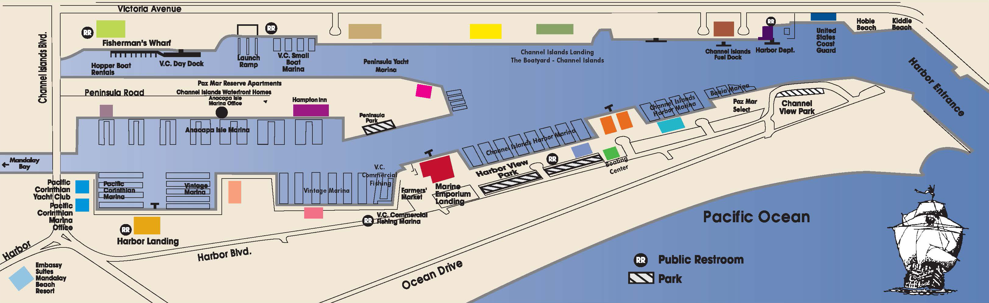
The Ventura County Harbor Department manages 310 acres (200 acres on land and 110 acres of water) comprising the Channel Islands Harbor. The Harbor Department’s offices are located on the E side of the Harbor about 400 yards N of the first bend in the channel. Guest slips are available. Visiting vessels should report to the Harbormaster for slip assignments. The Harbor Patrol monitors VHF-FM channels 12 (non-emergency) and 16 (emergency), 24 hours a day. The physical address for the Harbor Department is 3900 Pelican Way, Oxnard, CA 93035. The Harbor Patrol can be reached at (805) 973-5959.
The U.S. Coast Guard Station Channel Islands Harbor is located at 4201 Victoria Ave. Oxnard, CA 93035, just south of the Ventura County Harbor Patrol offices. Search and rescue vessels are stationed there. The station can be reached at (805) 985-9822 and pressing “0” for the operator.

Two full-service boat yards – The Boatyard – Channel Islands and Anacapa Boatyard & Marine Services – are located on the East side of the Harbor, about .5 mile N of the Harbor office.

Fill up on gas or diesel (no-bio diesel) at the fuel dock, located on the East side of the Harbor just North of the Ventura County Harbor Department offices (3900 Pelican Way, Oxnard, CA 93035). Water, ice, snacks and limited marine supplies are available at the fuel dock. The fuel dock is open from 7 a.m. to 5 p.m. every day and can be reached at (805) 984-1081.

The Channel Islands Harbor public boat launch ramp is located at 3001 Victoria Ave., Oxnard, CA 93035 within the E channel of the Harbor. Visitors can enter the boat launch ramp area at the Victoria Ave. and Curlew Way intersection. No commercial activity is allowed in the launch ramp.
Parking fees: Please pay at the pay station adjacent to the launch ramp. The pay station accepts bills, coins, and credit cards (Visa and Mastercard). Vehicle must display parking receipt face up on dash.
Day use fee: $16
Overnight (unoccupied): $23
Overnight (occupied): $65

The boat and trailer wash facility is located at the Launch Ramp. The facility is for boat and boat trailer washing only. The cost is $3.50 for the first five minutes. Only quarters are accepted.

Don't miss out!
Sign up for our email newsletter so you don't miss out on special events, updates, and visitor information!
Maps & Charts
The Channel Islands Harbor is Ventura County’s go-to destination for recreational boating and sportfishing. Before you explore the Harbor and beyond, check out our list of boating essentials.
A 147*51' - 327*51' measured nautical mile is off the breakwater and beach just N of the harbor entrance. The S range is marked by the breakwater S light and the S jetty light. The N range is marked by less visible poles on the beach.
Getting Here
The Channel Islands Harbor is one-mile NW of Port Hueneme and 5.8 miles SE of Ventura Harbor. The entrance is located between two jetties projected by an offshore breakwater. Each end of the breakwater and both the seaward and inshore ends of both jetties are marked by lights. A fog signal is at the seaward end of the south jetty. The area SE of the entrance is subject to rapid and uncertain shoaling. Mariners should exercise caution when approaching the Harbor from the S, especially at night. The entrance channel leads NE from the breakwater then turns N into the entrance basin. (Please refer to NOAA Navigation Chart 18720 or 18725 for chartered depth of the Harbor.)
COLREGS Demarcation Lines
The lines established for Channel Islands Harbor are described in section 80.112, chapter 2.